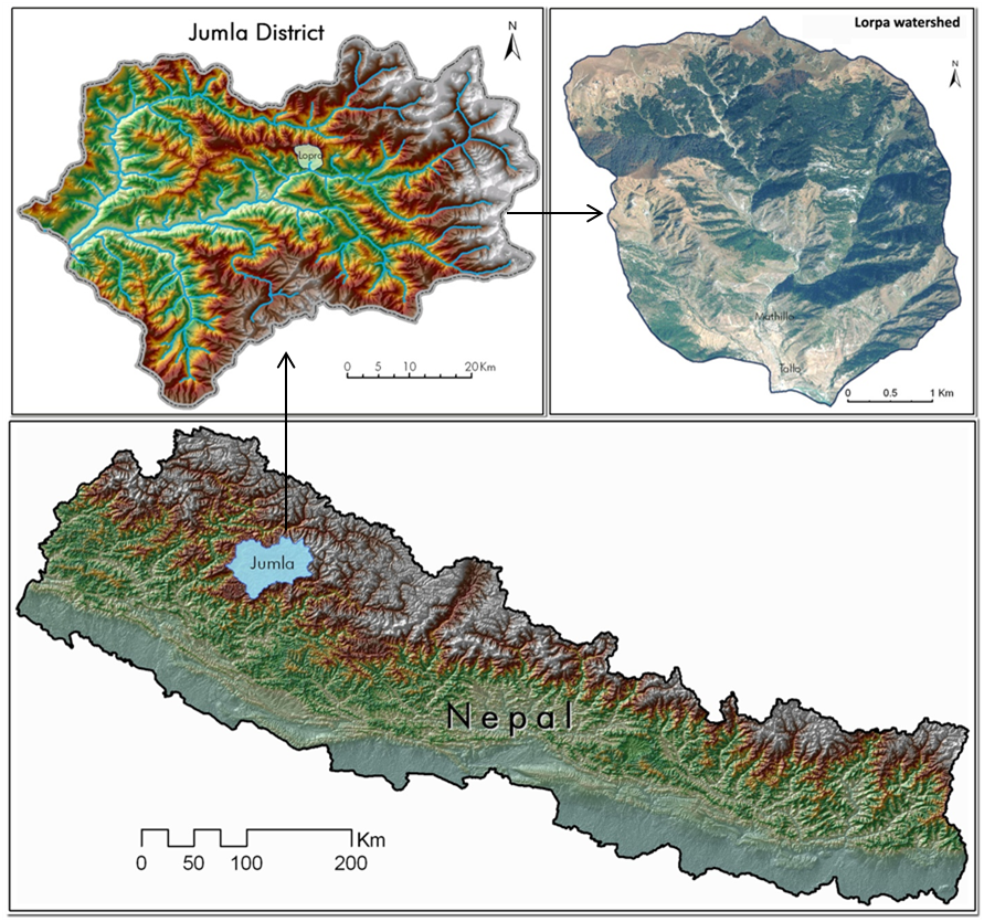
The study area, Lorpa watershed, is situated in mid-northern part of Jumla district, Nepal.
Total Study Area = 13 km².
Boundary coordinates:
Longitudes = 82.23E and 82.27E
Latitudes = 29.35N and 29.31N
Centre point coordinate:
Longitude = 82.26E
Latitude = 29.34N
Elevation(ASTER DEM)(mean seal level):
Minimum elevation = 2497 meters
Maximum elevation = 4078 meters
Slope
Highest slope = 77 degrees
Lowest slope = 0.5 degrees.
Below is the figure showing Virtual view of Lorpa watershed using Google Earth:
Forest fragmentation and edge assessment:
Forest fragmentation occurs when large, contiguous forests are divided into smaller patches due to natural processes and human activities. Area effects are most easily represented in terms of patch size. Based on a specified edge width in the generated land cover map, the forest is classified into core, perforated and edge zones.
Core: Core forests consist of any forest pixels that are more than 100 meters from non-forest. Core forest lies out of the edge effect zone and so is not degraded by fragmentation.
Perforated: Peripheral forest consists of forest pixels that are within 100 meters of non-forest and the tract contains core forest. Perforated place is within the edge effect zone along the edge of a small clearing in a non-patch tract (e.g. the forested area surrounding the cleared house lot and enclosed within the boundary at right).
Edge: Edge occurs within the edge effect zone along the outside edge of a non-patch tract (e.g. the forested area along the urbanized region and enclosed within the boundary at right).
Patch: Patch forests do not contain any forest pixels that are more than 100 meters from non-forest and they are entirely encompassed by the edge-effect.
Figure below shows the pictorial view of these types of fragmentation:
Forest fragmentation and Patch analysis:
Spatial Land cover change assessment carried out in 2006 and 2011 reveals that out of the total watershed area of 1304 ha, an area of 489 ha contributing to 37.5 % of the watershed has undergone change.
The forests area is reduced by 141 ha from the 634 ha forest cover of 2006.The loss of forests accounts to 22% of the 2006 forest cover with an annual deforestation rate of 4.5%.The conversion of forests mainly resulted into the increase of open shrubs and grasslands. Figure below depicts the landcover change during these study period:

Considering the degree of deforestation found in the watershed, the analysis of spatial distribution of forest and non forest areas have shown that out of 643 ha of total forests, only 47 ha are covered by core forests (forests located with 100 meters distance away from non forest).
The loss of these core forests by 2011 signifies the accessibility and vulnerability of forests for both anthropogenic and natural change factors.In addition the forest patches which do not have any forest cover close by 100 meter distance also have increased from 54 ha to 121 ha during 2006-2011.
The reduction of area under perforated and edge condition and increase in forest patches reveals the edge effects of deforestation. The enlarged view of the satellite image and forest landscape metrics depicting deforestation and associated transition in forest landscape metrics is shown in Figure below:

Spatial Land cover change assessment carried out in 2006 and 2011 reveals that out of the total watershed area of 1304 ha, an area of 489 ha contributing to 37.5 % of the watershed has undergone change.
The forests area is reduced by 141 ha from the 634 ha forest cover of 2006.The loss of forests accounts to 22% of the 2006 forest cover with an annual deforestation rate of 4.5%.The conversion of forests mainly resulted into the increase of open shrubs and grasslands. Figure below depicts the landcover change during these study period:
Considering the degree of deforestation found in the watershed, the analysis of spatial distribution of forest and non forest areas have shown that out of 643 ha of total forests, only 47 ha are covered by core forests (forests located with 100 meters distance away from non forest).
The loss of these core forests by 2011 signifies the accessibility and vulnerability of forests for both anthropogenic and natural change factors.In addition the forest patches which do not have any forest cover close by 100 meter distance also have increased from 54 ha to 121 ha during 2006-2011.
The reduction of area under perforated and edge condition and increase in forest patches reveals the edge effects of deforestation. The enlarged view of the satellite image and forest landscape metrics depicting deforestation and associated transition in forest landscape metrics is shown in Figure below:
Data Preparation of Lorpa Watershed
Study Report GIS And Remote Sensing based Study of Lorpa Watershed, Jumla prepared by:
Mountain Environment and Natural Resources’ Information System,
International Centre for Integrated Mountain Development
http://www.icimod.org, http://www.geoportal.icimod.org
Study Report GIS And Remote Sensing based Study of Lorpa Watershed, Jumla prepared by:
- Basanta Shrestha, Regional Programme Manager, MENRIS, ICIMOD
- MSR Murthy, Theme Leader, Geospatial Solutions, ICIMOD
- Birendra Bajracharya, Programme Coordinator, Regional Databases Initiative, ICIMOD
- Kabir Uddin, GIS and RS Analyst, ICIMOD
- Bikash Dangol, Research Associate, GIS Web Programming, ICIMOD
- Sameer Bajracharya, Research Associate, GIS, ICIMOD
- Laxmi Thapa, ICIMOD
Mountain Environment and Natural Resources’ Information System,
International Centre for Integrated Mountain Development
http://www.icimod.org, http://www.geoportal.icimod.org